Label Terrain Spots
 Used to label elevations at specific locations on the terrain model.
You can access this tool from the following:

| Setting | Description |
|---|---|
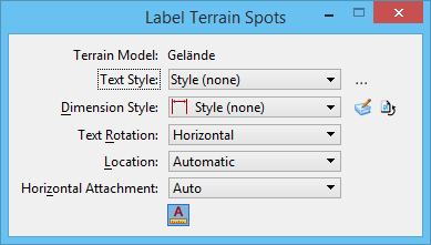
| Terrain Model | Name of the selected terrain model. |
| Text Style | Sets the current text style from a list of all available text styles.
To restore any text-related tool settings to the default text style settings, click the Reset Style icon. |
| Dimension Style | Sets the current dimension style from a list of all available dimension styles.
To restore any dimension-related tool settings to the default dimension style settings, click the Reset Style icon. |
| Text Rotation | Sets the rotation of the text relative to the leader line: Horizontal, Vertical, or In Line. |
| Location | Determines whether the leader line can be placed with multiple segments. If set to Manual, you can place multiple segments. If set to Automatic, you can only place one segment of a leader line. The default setting is set by the dimension style (Placement category). |
| Horizontal Attachment | Sets the leader attachment side: Auto, Left, or Right. |
| Annotation Scale Lock icon | If on, makes the elevation’s annotations use the active model’s annotation scale. |


